Skip to content

From Khirbet Mazin to Einot Tzukim

Share place

This is a challenging route that ascends Matzok HaEtekim up to the desert level and, on the way back, descends into the Einot Tzukim Nature Reserve.

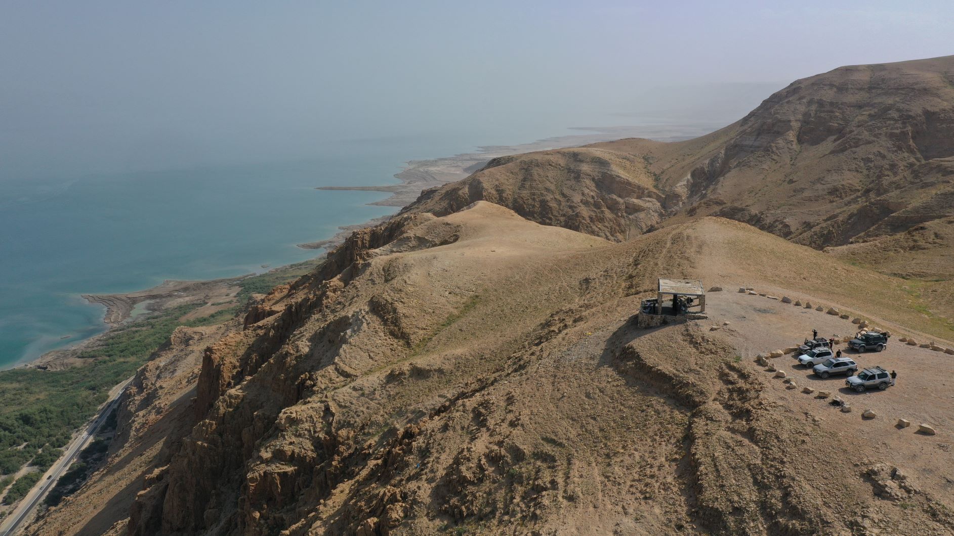
The trail climbs a challenging ascent to the top of the cliff, where the desert plateau spreads out before you, blooming and blossoming during the appropriate season, and arrives at a vantage point at Rosh Tzukim. From here, you can look out over Einot Tzukim Nature Reserve, see the retreat of the Dead Sea and perceive the sinkhole phenomenon.

From this point, the trail descends on a short and relatively easy track to Route 90, near the entrance to the nature reserve, which is highly recommended to visit.

Please note: you are passing through the Matzuk HaEtekim Nature Reserve. Please do not descend from the marked path and be sure to exit the reserve before dark.

  • Trail Length: approx. 7 kilometers
  • Trail Duration: approx. 6 hours
  • Suitable for Challenge-Seekers
  • Recommended Season: spring/autumn/winter
  • Trail Map: #8
  • Trail Marks: Color Green 8217/ Color Blue 8141/ Color Black 8216
  • Starting Point: at the entrance gate of Ovnat
  • Finishing Point: at the bus-stop by the entrance to the Einot Tzukim Nature Reserve


The itinerary, as described above, is a recommendation only, and those who choose to take this trip do so at their own discretion and responsibility. The Regional Councils will not be held accountable in the event of any adverse consequences that may ensue.

Due to Ministry of Health guidelines and ‘Purple Tag’ restrictions, advanced registration must be made in the online reservation system of the National Parks & Nature Reserves Authority.

General details about the place
  • Degree of Difficulty: for good walkers
  • Free Entry
  • Linear trip
  • Suitable alone
  • Suitable for families
  • Walking trail
Location on the map
Leave details and we will get back to you
Additional experiences that may interest you
Tracks
Duration: 02:00 hours

Enot Tsukim Nature Reserve

An oasis of amazing beauty with an abundance of sweet springs, plants and herbs that create a unique nature reserve...
Tracks

Rahaf Stream

Rahaf Stream is located south of Masada in one of the most beautiful and  impressive canyons in the Judean Desert. The stream begins in the Judean Desert  and ends in the Dead Sea, near Mount Elazar. It is 20 kilometers long with a  drainage area basin of nearly 80 square kilometers. The stream begins in the  Kenaiim Valley between Masada and Arad. From there, it makes its descent into  the Dead Sea. In Arabic, the stream is called “Wadi Khafaf,” which means “river  with rustling wings.”  The canyon of the stream is narrow and deep with many waterfalls and rapids. It  can be a challenging route and is suitable for rappelling, descending between the  rocks, crossing waterfalls with the help of ropes, and crossing the stream itself with  ropes, which can fill up after floods. In the middle of the canyon, at the point which  opens up a little and can be reachable without rappelling equipment, there is a  deep, shady, and beautiful ridge that was found filled for several months following  floods.​ At the stream, you’ll encounter Tristam’s starlings, which sometimes get so close  that they’ll eat from your hand.  There are green and blue trail marking throughout the route.    The itinerary, as described above, is a recommendation only. Those who choose to take  this trip do so at their own discretion and responsibility. The Regional Councils will not be  held accountable in the event of any adverse consequences that may occur. 
Tracks
Duration: 08:00 hours

Nahal Darga

The Nahal Darga canyon is one of the most challenging, difficult and beautiful hiking trails in Israel. The black-marked path, descending...
Cookies

This website use cookies to improve site functionality, provide you with a better browsing experience, and to enable our partners to advertise to you.

Detailed information on the use of cookies on this Site, and how you can decline them, is provided in our cookie policy.

By using this Site or clicking on “I agree”, you consent to the use of cookies.

On the map