Skip to content

Nahal Tamar – Nahal Tzafit

Share place

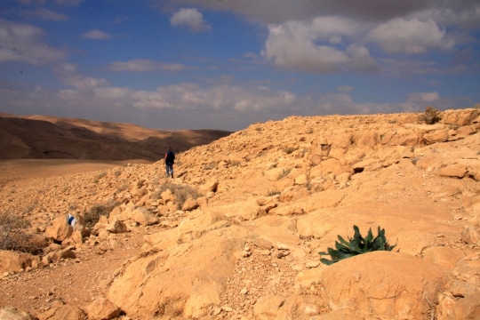
The Nahal Tamar/Nahal Tzafit trail, is a fascinating and challenging route with ladders, ropes, rock-stairs and, of course, a lookout-point with a beautiful view of the Dead Sea and the Arava desert valley.

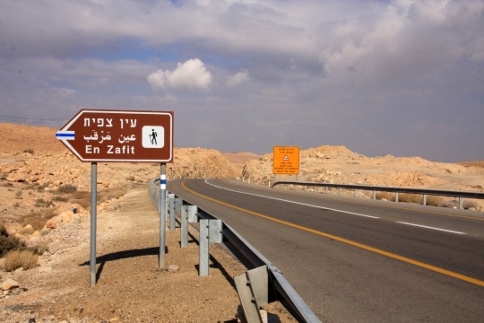
The trail is circular and begins at the Tamar drilling site, adjacent to the Arava Junction gas station.

At the beginning of the track, we’ll turn right at the green-marked path into the stream. We’ll begin to climb until reaching the ladders that will take us up to the ridge, which extends to the Small Crater. The ascent on the ladders is fun and challenging. But – don’t look down!

When reaching the top, we’ll continue on the green-marked path until meeting up with the blue-marked path. We’ll continue walking for about 30 minutes, until the path diverges into a black-marked trail leading into Nahal Tzafit. This trail will lead us back eastwards, towards the Dead Sea.

The walk back also takes about half an hour and, all along the route, you will be using ladders and recesses in order to cross steep passage-ways.

The exit from Nahal Tzafit will connect us to the red-marked path, that progresses along Route 90, back to the gas station/drilling-site.

  • Trail Length: approx. 3 kms
  • Trip Duration: approx. 4 hours, due to the character of the trail and the relatively slow walking speed.
  • Suited to challenge-seekers, but not especially difficult.
  • Recommended Season: Spring/Autumn/Winter
  • Trail Map # 14
  • Starting/Ending Point: adjacent to the Arava Junction gas station, on Route 90.


It is very important to pay attention to weather reports. It is prohibited to enter the trails when there is a fear of flash-flooding.

The itinerary, as described above, is a recommendation only, and those who choose to take this trip do so at their own discretion and responsibility. The Regional Councils will not be held accountable in the event of any adverse consequences that may ensue.

General details about the place
  • Degree of difficulty – medium
  • Free Entry
  • Requirement for Ancillary Equipment
  • Round trip
  • Suitable alone
  • Suitable for families
  • Walking trail
Location on the map
Contact us
Email|tourism@ma-tamar.co.il Address| Arava Junction gas station, on Route 90.
Phone|08-6688861
Hours of Activity|

24/7

Leave details and we will get back to you
Additional experiences that may interest you
Tracks

Mashash Muraba'at

Nahal Mashash is a typical stream in the Judean Desert with a steep canyon, various animals, and plants unique to...
Tracks

Nahal Og

The stream channels of Nahal Og begin in northeast Jerusalem, and run parallel to Route 1 on the way to...
Tracks

Rahaf Stream

Rahaf Stream is located south of Masada in one of the most beautiful and  impressive canyons in the Judean Desert. The stream begins in the Judean Desert  and ends in the Dead Sea, near Mount Elazar. It is 20 kilometers long with a  drainage area basin of nearly 80 square kilometers. The stream begins in the  Kenaiim Valley between Masada and Arad. From there, it makes its descent into  the Dead Sea. In Arabic, the stream is called “Wadi Khafaf,” which means “river  with rustling wings.”  The canyon of the stream is narrow and deep with many waterfalls and rapids. It  can be a challenging route and is suitable for rappelling, descending between the  rocks, crossing waterfalls with the help of ropes, and crossing the stream itself with  ropes, which can fill up after floods. In the middle of the canyon, at the point which  opens up a little and can be reachable without rappelling equipment, there is a  deep, shady, and beautiful ridge that was found filled for several months following  floods.​ At the stream, you’ll encounter Tristam’s starlings, which sometimes get so close  that they’ll eat from your hand.  There are green and blue trail marking throughout the route.    The itinerary, as described above, is a recommendation only. Those who choose to take  this trip do so at their own discretion and responsibility. The Regional Councils will not be  held accountable in the event of any adverse consequences that may occur. 
Cookies

This website use cookies to improve site functionality, provide you with a better browsing experience, and to enable our partners to advertise to you.

Detailed information on the use of cookies on this Site, and how you can decline them, is provided in our cookie policy.

By using this Site or clicking on “I agree”, you consent to the use of cookies.

On the map